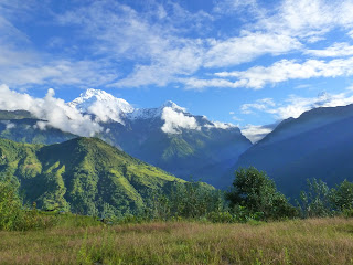
With our beastly journey to Syabrubesi behind us, Med, Luc and I set out on the trek through the Langtang valley with a spring in our step and the colours, views and scents of the valley made for an energising climb in the sunshine.
The forests were full of trees that seemed to be dripping with moss and ferns, the river was raging with glacial-melt waters, the birds and other animals chatted away oblivious to our
intrusion, and even the air seemed to take on a new, pure quality.The national park is sacred, so no animals can be killed within it, preserving it as a rich, natural paradise. Trekking through the forest-lined valley on the first day, we saw long-tailed, Gray Langur monkeys and the native species of, to quote, "a goat-like deer". We walked past flowers, bamboo and even thick plants of natural marijuana!
Unfortunately, with all that nature surrounding us, I did have a run in with a leech (on my back) within the first couple of hours. But, despite their sluggish, fanged demeanour, they are harmless and leave just a small, red mark in their wake. However, if you'd tried to tell me that at the moment I discovered its fat little body on my back I probably would have told you otherwise!
Unlike the leech, the monsoon season had left its mark on Langtang. We clambered up and down slippery pebbles, rocks and boulders, scrambling over toppled-over trees, jumping over destroyed parts of the trail and carefully shuffling over unstable logs and rocks to cross waterfalls. It filled us with a sense of adventure, but it was apparent how vulnerable the mountains, and their inhabitants, are at this time of year.

We arrived, happy and sweat-drenched, at Lama Hotel (2340m) - a strangely named settlement that would be our resting place for the night. After an afternoon greeting a few fellow trekkers in the sunshine, including Andreas and Marit who we'd met the day before, we huddled inside the spartan, wooden dining room of our lodge - 'Friendly View'. The sun dropped behind the mountains and the room was lit with just two, faint bulbs. Conversation about that day's trekking buzzed and we all relaxed in the hot glow of the log fire.
Suddenly, the lodge and the ground beneath it started shaking. Gripped with fear, I held on tightly to the bench I sat on. Another group's porters rushed into the room and a few people started scrambling, terrified, to the door. Landslide, I thought, my heart pumping in my chest. But soon the shaking, lasting just 30 seconds, came to a stop and we all stood in suspended disbelief. Earthquake, I then thought, and I was right. I went outside, feeling a little claustrophobic now in the small lodge, and asked the hotel owner what had happened.
News crackled in on the mountain radio, first that the quake had been in Tibet, and later that it had in fact been in Sikkim, India, which borders Nepal in the east. Shaken, quite literally, we went to bed wondering what else the Langtang valley would have in store for us.
Over a breakfast of cement-like porridge, we heard the sad news that a few people had been killed in Kathmandu, where the buildings are held together with tangles of electricity cables and broken rocks on roofs. Later, we would learn that even more had died in Sikkim and many more still missing there, in the very same mountain range we were exploring.

Clouds had started to roll in and there was a patter of rain as we walked through thick forest on the second day. The river crossings became a test of agility and in my mind that day was the picture of the American girl from the poster who had gone missing 18 months before on the same stretch of the trek.
Although we had climbed up to over 3000 metres and had emerged from the forest, the mountains were still soaring high above us, disappearing into the mist that now blanketed the valley. We arrived in Langtang (3300m) and found the old village to be an enchanting collection of stone and wood-carved houses with more stone walls and pathways winding between them.
Seeking shelter and warmth at the 'Shangri-La' lodge, I spent the afternoon looking after the family's four month old baby, who was layered in over-sized clothes and seemed to enjoy my English nursery rhymes.
Seeking shelter and warmth at the 'Shangri-La' lodge, I spent the afternoon looking after the family's four month old baby, who was layered in over-sized clothes and seemed to enjoy my English nursery rhymes.
 The small lodges up the mountain are wooden
and basic and, as the temperatures drop in the evening, you can find yourself sat around the fire with the family who own the house and even in the kitchen, watching them preparing the evening meals. The mountain folk of Langtang are made up of three main ethnic groups: Tamang, Hyolmo and Bhotia - our experience was that they were all in some way related to each other, with many brothers and sisters in the different settlements along the trek.
The men of the mountain wear anything from herringbone vests and faded shirts to moth-eaten North Face fleeces and faux-leather jackets. Those who dutifuly serve as trekking guides are easily identified by their crunched-up toes, made so by years of gripping rough mountain trails wearing nothing more than thin, rubber flip-flops.
Contrasting with the muted browns of the men’s garments, the women of Langtang are wrapped in brilliant dresses that paired colours and patterns that would be incongruous in the western world, but somehow here seemed to match perfectly. They also wear the traditional brass earrings of the valley people - heavy, the earrings are supported with loops of pink or red wool. Their hair, that has never been cut, is usually tied in a single, long, shiny braid down their back.
 Like the local people, we started to adjust to going to bed early and rising not long after dawn. But that night I had an altitude-interrupted sleep and awoke with a the start of a cold. We trekked slowly upwards, through the mist. I started to get a bad headache, which can be a symptom of altitude sickness. After an hour sat in a wooden hut nursing a cup of tea, Andreas and Marit, both medics, advised Med and I to go back down to Langtang to err on the side of caution. So, just half an hour from our next stop, we descended for another night's acclimatisation at Langtang village - hoping we would meet the others the following day.
With my head feeling a bit clearer the next day, we set off again up the same path. Thankfully,
the mist had lifted somewhat and we could see the view of the valley for the first time in two days. Each little settlement we passed was preceded by a line of stone mani walls, inscribed with Buddhist mantras to guard the towns and offer safe travels to those that pass. We ensured we passed them to the left as is tradition and enjoy spotting large, hairy yaks dotted all around.
Higher up, past the tree line, lies the village of Kanjin Gompa (3800m), named after the white,

sloping walled gompa (small, Buddhist monastery) that lies at the junction of the Lirung valley with the Langtang Valley. Approaching the settlement, we were surrounded by massive rocks protruding out of the now faint breaths of mist. We picked our way around the lodges of the villages, with kitchens blowing out fire smoke, finding where our three trekking friends were staying.
It was so very cold in the village and, wrapping myself up in borrowed blankets for the afternoon, I suffered more flea bites than I dared count. Still, the Tibetan bread and yak cheese (from Kanjin Gompa's cheese factory) made up for it - as did the sublime sunset view of the white mountains that towered over us on all sides.

The next morning it was still clear and we assembled at 5am to start our summit up to Kyimoshung (4640m). Still suffering with a cold, I was about 80 plods behind the group, my lungs and legs feeling heavy in the thin air. I struggled up sand (a reminder of just how new the Himalaya are) and eventually, exhausted, reached the top.
It was a luminous morning up high in the mountains, with sharp, iced peaks, outlined in blue every way we looked, including Langtang Lirung (7227m). We stood right next to a glacier that looked as if a river had just frozen - suspended and rugged. The brightness was almost blinding and we enjoyed the heat of the sun on our backs as we took in the panorama.

After three days of mist, we had earned this view.
The Langtang valley gave us pine forest, shifting clouds, swift mountain streams, ribbons of waterfalls, rugged landslides, glaciated mountains giants, grassy meadows strewn with flowers and yak cheese to share with new friends. We made our descent down feeling thoroughly content, steeply up and steeply down the labyrinthine valley.
The Langtang valley gave us pine forest, shifting clouds, swift mountain streams, ribbons of waterfalls, rugged landslides, glaciated mountains giants, grassy meadows strewn with flowers and yak cheese to share with new friends. We made our descent down feeling thoroughly content, steeply up and steeply down the labyrinthine valley.