Showing posts with label trek. Show all posts

Wednesday, 19 September 2012

Finding our way to La Ciudad Perdida

Clinging to a rickety, brightly-coloured jeep as it blindly hurtles around a dusty mountain road with a group of Irish, two Danes and two Colombians could only mean one thing: we were off to get “lost” in the Colombian jungle.
Team photo, day 1

Colombia's recent civil war makes the mere utterance of the country's name evoke images of kidnappings, drug lords, left wing guerrillas, and right wing paramilitary death squads.

And so what we were about to do - trek through dense jungle notorious for guerrilla, paramilitary activity and cocaine production - might be enough to send some people flailing in the other direction. Us, well we had it as our “must do” for South America!

Camp day 1, surrounded by flowers
Colombia's Ciudad Perdida (Lost City) would be mentioned in the same breath as Machu Picchu if it wasn't so hard to reach, with the added fear factor. Teyuna is the indigenous name of the city, built by the Tayrona Indians in the Sierra Nevada around 800AD.

The overgrown city, which was re-discovered 1976, lies inland of the Caribbean coast of Colombia, where the jungle is swamped with the sticky humidity rising from the coast. For years it was hidden from the world under the thickest canopy of trees and only the descendants of the Tayrona Indians even knew it existed.

Hammocks
Part of the appeal of this mysteriously remote city of thousands is its inaccessibility: steep climbs, slippery mud, waist-high river crossings and venomous creepy crawlies lie in wait.

And so we set off with our guide, Omar, who called all the girls “mi amor” (my love) or “mi novia” (my girlfriend), Luis, our wise and grinning chef, and Antonio, our assistant guide and music maestro (with the tunes played through his battered phone).

Our first day of walking, from the village of Machete through the humid jungle, brought us to our first camp - full of huge, tropical flowers of luminous orange, crimson and hot pink.

Roommates
The camp was equipped with a sheltered area for our hammocks and mosquito nets, and beautiful butterflies, and then later sparkling fireflies.

After a refreshing swim (and bath!) in a nearby swimming hole, where we jumped off rocks into the deep cool pool below, we drank a hot cup of Colombian “tinto” (strong, black coffee) and the Irish cracked open one of the five litres of rum they had in the backpacks.

That night, I perfected the art of diagonal hammock sleeping and slept better than everyone. It’s all in the angle.

Indigenous Tayrona children
On the second day, between sweating out rivers of perspiration and plunging into streams to wash off, we visited an indigenous village. The Kogi people, direct descendants of the builders of Ciudad Perdida, the Tayrona, have only recently begun to come around to tourists visiting their communities and most sacred site.

Us tourists are merely tolerated, in exchange for money (they receive $80,000 each year from tourists) and food. Although, if you’re from Spain, you have to keep on walking. They still do not tolerate the Spanish.

Omar and Antonio, our guides
The settlements consisted of a few wooden huts with chickens running in the cleared spaces between the crops. The Kogis were courteous but unfussy; only their children seemed excited as they ran about in what once must have been white outfits - the cloth is now closer to the orange colour of the soil.

Omar greeted one of the villagers, who proudly sported wellington boots and a man bag, which seem to demonstrate his importance. He looked sullenly away from us as the children who ran up for bread beamed.

Bath time!
The evenings on the trek were passed in sideless wooden shelters, with space to hang our sweat and deet soaked clothes and unspoilt views of the afternoon monsoon and, later, the impenetrable darkness.

Five days in total, the trek was arduous, climbing a muddy trail to the top of one mountain after another, only to have to descend on the other side each time.

The heat and humidity was overpowering at times and all the water we could drink did not keep us hydrated. Add to this the fact that I got food poisoning and I had myself quite a personal challenge on my hands. But I was determined to make it to this mythical city.

Despite being reassured it is “seguro” (safe) now, we couldn’t escape the tale of the 2003 kidnapping and chatter about what we would do if we were kidnapped.

Tayrona Tarzan (Med)!
A guerrilla group known as the ELN kidnapped eight foreigners, who were hiking to Ciudad Perdida with the tour company we were using. They held them for three months, forcing them to walk through the mountainous jungle with little food and water.

The foreigners were eventually freed after weeks of negotiations with governments. It wasn't until 2005 that the military was sent in, allowing treks to the Lost City to resume safely, but there was still that spine-tingling element of fear for me.

When it rained, it poured
On the fourth day, we set out early to La Ciudad. But first, we had to wade through the now waist-high, fast-flowing river, heaving after yesterday’s storm.

We made it, and so did the tiny black dog who insisted on following us, despite being nearly dragged down the raging river. South American dogs will do anything for a tickle behind the ears and a few food scraps.

So, after a brief scramble to the river and a near drowning of our canine friend, we clambered up the 1,200 steep, wet steps to the city.

Kogi village
While I was vomiting in a jungle toilet two nights before, I met the man whose father discovered the Ciudad Perdida. Hero, I thought. Golddigger, it turned out .It was three golddiggers who re-discovered the jungle-choked city in 1973 and started to dig for their fortunes.

The existence of the city was only revealed to the rest of Colombia when the golddiggers got greedy and one murdered the other during a gravedigging outing.

Despite excavations since that time, the jungle still swarms over the stone terraces where the Kogi Indians once lived and farmed on the carved terraces and raised circular plazas. And so we only got to see a small part of the Ciudad Perdida.

The morning's clouds had lifted themselves up over the mountains, to reveal a breathtaking canopy of primeval forest tumbling down into the canyon carved by the Buritaca river.

Only the wildest of imaginations could believe that Caribbean beaches lie less than 50km to the north; in this world there is only jungle.

Carved out on the top of this mountainous jungle, around eighty, circular raised stone platforms are scattered over a 4km radius. Each stone once supported the wooden huts that were the homes, meeting places and dormitories of the villagers.

River crossing - scary at times!
A larger central plateau was where harvested crops were brought and meetings were held. Men and women were kept very separate, with the men putting on a hunting show for entertainment while the women kept to their own square.

We sat on the chief’s throne, and walked the ceremonial staircase. It was here couples to be wed walked down to the river to signify to the rest of the tribe that they were to marry.

La Ciudad Perdida
This was also the escape route for the woman if she did not want to marry the man, but she had to be able to outrun her suitor and make the journey all the way around the valley to re-enter the settlement from the other side. Today, we have the likes of Jeremy Kyle for this kind of thing.

Today, only the army run around the city, camping out on the small exposed area of the ruins and posing for photos with brave tourists. Like everywhere in South America, they were heavily armed with guns and explosives.

We walked around the beautifully mysterious site, imagining the life people led here amidst the trees, butterflies and thousands of mosquitoes.

The chief's throne
It would be possible to spend years hacking into the parts of the city that remain tangled in roots and earth, but I think that the jungle will win in the end, keeping some secrets lost forever within it.

Some secrets did unravel a few days later, however, when we discovered that $150,000 Colombian pesos (about £51) is payment to the Los Paramilitares who still stalk the area.

La Ciudad Perdida
Criss-crossing fireflies were not the only things present in the forest’s eerie darkness; we were walking shoulder to shoulder with them, hiking into the remote Colombian jungle.

Thursday, 21 June 2012

Volcan Chachani: dry heaving in an igloo

This is not an event I was eager to relive - but how can I let my three-strong blog fanbase down?! You have to document the rough with the smooth; travelling isn't all a walk in the park.
Chachani from Arequipa

6,000 metres above sea level is a height Med and I have never been to before, not even in the mountain capital of the world: Nepal. My sky dive in New Zealand was only 4,572metres (15,000ft).

What we were about to do would mean camping higher than I'd jumped out of that small plane. That should have been my first warning.

We went to the tour agency to meet our fellow trekkers, Alex and Nick from Switzerland, and to get kitted up in retro snow and ice gear that was last in fashion in the 80s - because that was when it was made. We were hoping to summit Volcan Chachani - a very serious 6075m.

Arequipa is situated in a broad valley, surrounded by three imposing volcanoes. You look anywhere towards horizon, you will see the brooding bulk of one of the volcanoes - El Misti, Chachani or Picchu Picchu. Picchu is ‘peak’ in Quechua language; Picchu Picchu means the plural: ‘peaks’.

Spirits were high as we started our trek
Chachani is the highest of the volcanoes in that region at 6,075m. In the Quechua language (the first language of the Andes), Chachani means 'skirt'; and a female character is normally attributed to the mountain in local legends.

Chachani has extremely low levels of precipitation and is therefore unusual as it does not have a permanent ice cap or glaciers. This means apart from the obvious problems with altitude it is one of the few 6,000m mountains in the world that can be attempted by inexperienced climbers.

You need to be armed with an ice pick but you don't necessarily need to know how to use it.

We left for the Chachani trailhead around 8:30am and drove a long, winding 4 wheel track (that at times barely looked like a road). It’s literally a mind-numbing drive from Arequipa (2,400m) to the start of the trek (5,018m) and even our acclimatised bodies could feel the affects.

The 4WD left us, surrounded by white peaks, to hike a couple hours to the base camp - made difficult with our shoulder-pinching, back-numbing 20kg backpacks containing all our gear. Camp (5,200m) was a beautiful spot on sand where we pitched the tents and settled in for some food. There were only two other people doing the trek, so just six of us and two guides in total.

Camp: 5,200metres
Med and I watched sunset next to a little, curly-tailed chinchilla, and then settled in to get some sleep at 5.45pm ready for our 1am wake-up call. You have to summit in the dark as any later and there is a risk of avalanches.

Despite my knack for being able to sleep anywhere, I only manage a few short stints of sleep, often found myself waking to my head thumping due to the lack of oxygen. I had had a dodgy stomach the day before and now it was coming back to haunt me. I felt so weak.

Acclimatisation and recent experience trekking at altitude clearly doesn't matter if you're not 100% fit and healthy.

Med managed to get some sleep, but I had six hours of misery and very little sleep.

Stunning sunset over the mountains
At 1am we all rose into the icy air and the nausea hit me right in the guts. I tried coca leaves, altitude sickness tablets and coca tea but we had a tight time schedule and my nausea wasn't going anywhere fast.

My stubbornness subsided and I got back in the tent, into two sleeping bags this time, as well as two hats and two pairs of gloves. It's so horrible to give up on something you really want to do, especially when you then have to lie in a tent at -15 degrees for 8 hours while everyone else gets to watch sunrise up a 6,000m volcano.

For the next hour, I dry heaved into a carrier bag as I watched the whole tent turn into ice around me - making a loud scratching and cracking noise that made it impossible to sleep.
It got a lot more frozen than this!
So there I lay in my igloo, alone, in the dark, at 5,200m. Eventually, after a few hours of drifting, I slept and woke just before the others returned from a really tough trek, looking dirty and exhausted.

Here's a few photographs Med took - so you don't need to miss out like I did!
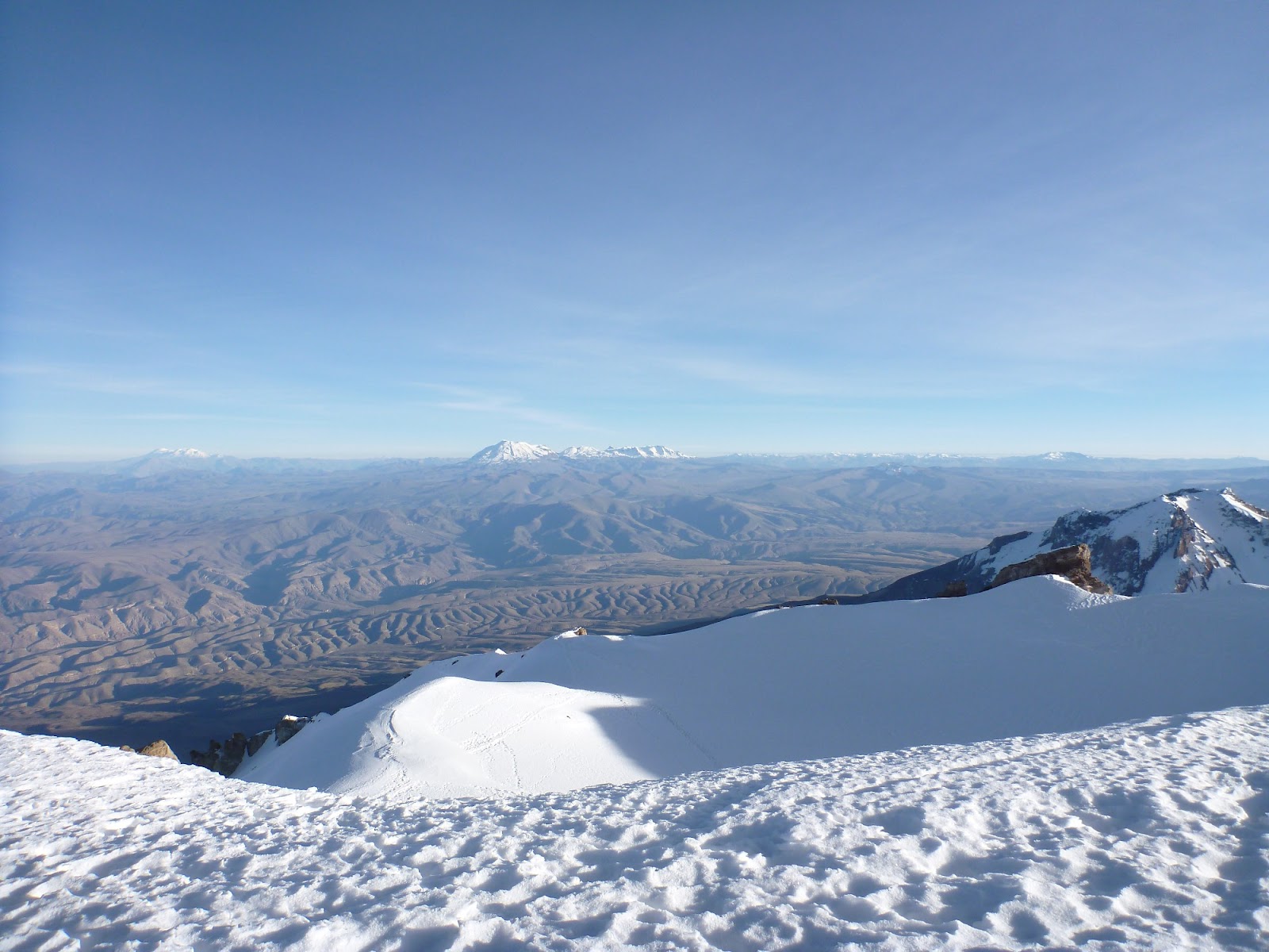
Summiting in the dark
The morning shadow of El Misti volcano over Arequipa

The summit of Chachani: 6,075metres
Like the altitude, the sickness and headache lessened throughout the morning, and by the time we were back in Arequipa I was fine, just feeling a bit glum. We've been so lucky with our treks and expeditions in the last ten months - I'm so much more grateful for that now.

6,000 metres, you'll be mine someday!

Tuesday, 19 June 2012

Colca Canyon: the world's (maybe second) deepest canyon

Of all our time on this earth, there have been very few occasions when Med and I have had to set an alarm for 2.00am. Our trip to Colca Canyon was one of these rare occasions.

Soaring, Andean condor
As we were getting ready in the middle of the night, others were no doubt still queueing to get into clubs on the other side of town; Arequipa, after all, is one of the top nightlife spots in Peru.

It didn't start well: the bus was 30 minutes late and showed no signs of our friend, James, who we first met over a month ago in Bolivia.

After a stand-off, a telephone call and making the driver promise we would see James at the other end, we eventually admitted defeat and climbed on board, giving a quick ‘hola’ and apologetic smile to our fellow, sleepy trekkers, and settled in the seat to try and get some shut eye that our bodies were crying out for.

At the bottom of the 2nd deepest canyon in the world!
Twice as deep as the Grand Canyon (though the walls aren’t as sheer), the Colca Canyon is somewhere between 3191 and 4160 metres (it's vague!) - maybe only second deepest in the world to the the Cotahuasi Canyon situated further to the north west of Peru.

There is much dispute around the world on this - some argue Colca is the deepest and Nepal claims on this title too.

Five hours later with a small stop in Chivay for breakfast and to pay our entrance fee to the national park, we arrived at our first stop, Cruz del Condor, the primary viewing location for Andean Condors.

Is anyone home?!
It seemed everyone got the memo though; we were in no way alone to enjoy this impressive bird with a wingspan of up to 10 feet and the ability to fly at altitudes of up to 16,000 feet. Oh no - anyone would think we were in Animal Kingdom, Florida with all the camera clutching, brimmed hat wearing tourists flooding the viewing platform.

Thankfully, in the crowd, we found our fellow trekker, James. We were going it alone, without a guide or a plan, and things were finally back on track.

Putting our feet up in our hospedaje, Ta Pay
When I blocked out the tourist circus for a few seconds, it was incredible to see one of the biggest birds in the world up close. They soared gracefully, rising up on the warm airs from deep in the canyon ready for a day's hunting - they are very heavy and rely on strong updrafts to be able to fly.

We also saw hummingbirds, giant and small, floating on air around us.

We then got dropped off at the start of the trek, San Miguel, quickly cutting away from the guided groups so we could have the canyon, and its lofty, cliff-cut views, to ourselves. The terrain was harsh and dry, the slopes steep and constant, until we reached the river in the bottom.

Keeping warm in our barn room
Then it was up, up and up, deciding to continue trekking past the small village of San Juan (in truth, we actually couldn't find it!) until we thought we had reached Ta Pay.

There was no one in the six or seven mud huts here, despite our shouts of "hola" into the fresh, silent air.

After 15 minutes, we were almost considering going back down to find San Juan, and then a small man ambled down the path and shed some light: Ta Pay was still another 30 minute climb up.

Making friends with the donkeys
Ta Pay was a small village high up on one side of the canyon, fringed with mountains behind and the depths of the canyon in front.

Again, it appeared to be a ghost town, the church eerily empty and dark. Until we found the football game in a concrete yard and someone who had a basic hospedaje.

The guy who ran it, probably in his early 30s, lived there by himself, working the land and occasionally getting some money from tourists. His family all lived away - incredible the simple, hardy and isolated life these people had.

Our accommodations were certainly rustic - more like a barn with beds - but thoroughly impressive given that the only way to get to the village is to hike or ride a mule.

Snake man
Right about then, we knew we had made the right decision to avoid the tour groups as we sipped on our long neck beer, the only tourists in the village (the last people wrote in the visitors' book over a month before), chatting away into the night under the best starry sky I've seen.

The next day was a lot easier, scaling the canyon side but in a gentle, downward direction. We saw ancient Inca 'tombs' - holes chiseled out of the steep canyon cliff to keep the bodies of their dead. And then along came a man holding a live snake - "comer" he smiled - to eat. We shared the route only with locals and their scruffy-looking donkeys and mules.

Cute little Quechan girl
After a few hours we reached San Galle, known as "Oasis" as, in the middle of all the barren rock and stone, this place is saturated with lush green vegetation and palm trees. Oasis was quite the place to unwind after two days trekking, with several quaint hostels all with swimming pool and a bar.

Stunning views of the canyon
Our hut wasn’t the most luxurious of places, but how many times does one get to stay the night in a bamboo hut at the bottom of the second deepest canyon in the world? We lazed by the pool until sundown, then played cards and ate dinner with our fellow trekkers.

The next morning it was up at 5am in the dark to hike the gruelling, steep face of the canyon to catch our bus at 9.30am. Sunrise was beautiful, between puffs and glugs of water.

Chilling in the pool at Oasis
We raced up the canyon, the boys seemed to make it their mission to overtake every single person.

Cue the motivational music on my iPod and the destroying of my emergency biscuits (all three packets of them).

But make it we did, in half the time we'd given ourselves - just one hour and three quarters.

To top off a great three days trekking Colca, we got an amazing, free buffet lunch due to the cock-up with buses on the first day.
Sweaty, exhausted but we made it!

Backpacking life doesn't get better than a stunning trek and a free lunch.