Thursday 21 June 2012

Volcan Chachani: dry heaving in an igloo

This is not an event I was eager to relive - but how can I let my three-strong blog fanbase down?! You have to document the rough with the smooth; travelling isn't all a walk in the park.
Chachani from Arequipa

6,000 metres above sea level is a height Med and I have never been to before, not even in the mountain capital of the world: Nepal. My sky dive in New Zealand was only 4,572metres (15,000ft).

What we were about to do would mean camping higher than I'd jumped out of that small plane. That should have been my first warning.

We went to the tour agency to meet our fellow trekkers, Alex and Nick from Switzerland, and to get kitted up in retro snow and ice gear that was last in fashion in the 80s - because that was when it was made. We were hoping to summit Volcan Chachani - a very serious 6075m.

Arequipa is situated in a broad valley, surrounded by three imposing volcanoes. You look anywhere towards horizon, you will see the brooding bulk of one of the volcanoes - El Misti, Chachani or Picchu Picchu. Picchu is ‘peak’ in Quechua language; Picchu Picchu means the plural: ‘peaks’.

Spirits were high as we started our trek
Chachani is the highest of the volcanoes in that region at 6,075m. In the Quechua language (the first language of the Andes), Chachani means 'skirt'; and a female character is normally attributed to the mountain in local legends.

Chachani has extremely low levels of precipitation and is therefore unusual as it does not have a permanent ice cap or glaciers. This means apart from the obvious problems with altitude it is one of the few 6,000m mountains in the world that can be attempted by inexperienced climbers.

You need to be armed with an ice pick but you don't necessarily need to know how to use it.

We left for the Chachani trailhead around 8:30am and drove a long, winding 4 wheel track (that at times barely looked like a road). It’s literally a mind-numbing drive from Arequipa (2,400m) to the start of the trek (5,018m) and even our acclimatised bodies could feel the affects.

The 4WD left us, surrounded by white peaks, to hike a couple hours to the base camp - made difficult with our shoulder-pinching, back-numbing 20kg backpacks containing all our gear. Camp (5,200m) was a beautiful spot on sand where we pitched the tents and settled in for some food. There were only two other people doing the trek, so just six of us and two guides in total.

Camp: 5,200metres
Med and I watched sunset next to a little, curly-tailed chinchilla, and then settled in to get some sleep at 5.45pm ready for our 1am wake-up call. You have to summit in the dark as any later and there is a risk of avalanches.

Despite my knack for being able to sleep anywhere, I only manage a few short stints of sleep, often found myself waking to my head thumping due to the lack of oxygen. I had had a dodgy stomach the day before and now it was coming back to haunt me. I felt so weak.

Acclimatisation and recent experience trekking at altitude clearly doesn't matter if you're not 100% fit and healthy.

Med managed to get some sleep, but I had six hours of misery and very little sleep.

Stunning sunset over the mountains
At 1am we all rose into the icy air and the nausea hit me right in the guts. I tried coca leaves, altitude sickness tablets and coca tea but we had a tight time schedule and my nausea wasn't going anywhere fast.

My stubbornness subsided and I got back in the tent, into two sleeping bags this time, as well as two hats and two pairs of gloves. It's so horrible to give up on something you really want to do, especially when you then have to lie in a tent at -15 degrees for 8 hours while everyone else gets to watch sunrise up a 6,000m volcano.

For the next hour, I dry heaved into a carrier bag as I watched the whole tent turn into ice around me - making a loud scratching and cracking noise that made it impossible to sleep.
It got a lot more frozen than this!
So there I lay in my igloo, alone, in the dark, at 5,200m. Eventually, after a few hours of drifting, I slept and woke just before the others returned from a really tough trek, looking dirty and exhausted.

Here's a few photographs Med took - so you don't need to miss out like I did!
Summiting in the dark
The morning shadow of El Misti volcano over Arequipa

The summit of Chachani: 6,075metres
Like the altitude, the sickness and headache lessened throughout the morning, and by the time we were back in Arequipa I was fine, just feeling a bit glum. We've been so lucky with our treks and expeditions in the last ten months - I'm so much more grateful for that now.

6,000 metres, you'll be mine someday!

Tuesday 19 June 2012

Colca Canyon: the world's (maybe second) deepest canyon

Of all our time on this earth, there have been very few occasions when Med and I have had to set an alarm for 2.00am. Our trip to Colca Canyon was one of these rare occasions.

Soaring, Andean condor
As we were getting ready in the middle of the night, others were no doubt still queueing to get into clubs on the other side of town; Arequipa, after all, is one of the top nightlife spots in Peru.

It didn't start well: the bus was 30 minutes late and showed no signs of our friend, James, who we first met over a month ago in Bolivia.

After a stand-off, a telephone call and making the driver promise we would see James at the other end, we eventually admitted defeat and climbed on board, giving a quick ‘hola’ and apologetic smile to our fellow, sleepy trekkers, and settled in the seat to try and get some shut eye that our bodies were crying out for.

At the bottom of the 2nd deepest canyon in the world!
Twice as deep as the Grand Canyon (though the walls aren’t as sheer), the Colca Canyon is somewhere between 3191 and 4160 metres (it's vague!) - maybe only second deepest in the world to the the Cotahuasi Canyon situated further to the north west of Peru.

There is much dispute around the world on this - some argue Colca is the deepest and Nepal claims on this title too.

Five hours later with a small stop in Chivay for breakfast and to pay our entrance fee to the national park, we arrived at our first stop, Cruz del Condor, the primary viewing location for Andean Condors.

Is anyone home?!
It seemed everyone got the memo though; we were in no way alone to enjoy this impressive bird with a wingspan of up to 10 feet and the ability to fly at altitudes of up to 16,000 feet. Oh no - anyone would think we were in Animal Kingdom, Florida with all the camera clutching, brimmed hat wearing tourists flooding the viewing platform.

Thankfully, in the crowd, we found our fellow trekker, James. We were going it alone, without a guide or a plan, and things were finally back on track.

Putting our feet up in our hospedaje, Ta Pay
When I blocked out the tourist circus for a few seconds, it was incredible to see one of the biggest birds in the world up close. They soared gracefully, rising up on the warm airs from deep in the canyon ready for a day's hunting - they are very heavy and rely on strong updrafts to be able to fly.

We also saw hummingbirds, giant and small, floating on air around us.

We then got dropped off at the start of the trek, San Miguel, quickly cutting away from the guided groups so we could have the canyon, and its lofty, cliff-cut views, to ourselves. The terrain was harsh and dry, the slopes steep and constant, until we reached the river in the bottom.

Keeping warm in our barn room
Then it was up, up and up, deciding to continue trekking past the small village of San Juan (in truth, we actually couldn't find it!) until we thought we had reached Ta Pay.

There was no one in the six or seven mud huts here, despite our shouts of "hola" into the fresh, silent air.

After 15 minutes, we were almost considering going back down to find San Juan, and then a small man ambled down the path and shed some light: Ta Pay was still another 30 minute climb up.

Making friends with the donkeys
Ta Pay was a small village high up on one side of the canyon, fringed with mountains behind and the depths of the canyon in front.

Again, it appeared to be a ghost town, the church eerily empty and dark. Until we found the football game in a concrete yard and someone who had a basic hospedaje.

The guy who ran it, probably in his early 30s, lived there by himself, working the land and occasionally getting some money from tourists. His family all lived away - incredible the simple, hardy and isolated life these people had.

Our accommodations were certainly rustic - more like a barn with beds - but thoroughly impressive given that the only way to get to the village is to hike or ride a mule.

Snake man
Right about then, we knew we had made the right decision to avoid the tour groups as we sipped on our long neck beer, the only tourists in the village (the last people wrote in the visitors' book over a month before), chatting away into the night under the best starry sky I've seen.

The next day was a lot easier, scaling the canyon side but in a gentle, downward direction. We saw ancient Inca 'tombs' - holes chiseled out of the steep canyon cliff to keep the bodies of their dead. And then along came a man holding a live snake - "comer" he smiled - to eat. We shared the route only with locals and their scruffy-looking donkeys and mules.

Cute little Quechan girl
After a few hours we reached San Galle, known as "Oasis" as, in the middle of all the barren rock and stone, this place is saturated with lush green vegetation and palm trees. Oasis was quite the place to unwind after two days trekking, with several quaint hostels all with swimming pool and a bar.

Stunning views of the canyon
Our hut wasn’t the most luxurious of places, but how many times does one get to stay the night in a bamboo hut at the bottom of the second deepest canyon in the world? We lazed by the pool until sundown, then played cards and ate dinner with our fellow trekkers.

The next morning it was up at 5am in the dark to hike the gruelling, steep face of the canyon to catch our bus at 9.30am. Sunrise was beautiful, between puffs and glugs of water.

Chilling in the pool at Oasis
We raced up the canyon, the boys seemed to make it their mission to overtake every single person.

Cue the motivational music on my iPod and the destroying of my emergency biscuits (all three packets of them).

But make it we did, in half the time we'd given ourselves - just one hour and three quarters.

To top off a great three days trekking Colca, we got an amazing, free buffet lunch due to the cock-up with buses on the first day.
Sweaty, exhausted but we made it!

Backpacking life doesn't get better than a stunning trek and a free lunch.

Thursday 7 June 2012

One of the seven wonders: Machu Picchu

A tingle crawled from the bottom of my spine. Up to that point it hadn’t seemed real. But I was suddenly struck with the full force of reality at 4am: I was going to Machu Picchu, visiting the "Lost City" of the Incas.

Our first view of Machu Picchu
We were up, as we learnt from our Aussie friends, 'at a sparrow's fart!' I climbed out of bed and watched the cloud forest emerge from inky blackness, but I was still hopeful for sunny skies. Apparently every day at Machu Picchu starts like this.

A room with a view: the priest's house
We were first in the queue for the first bus up - you can walk but we wanted to save our stiff legs and sore feet for a full day of exploring. A 20-minute bus ride carried us up the zig-zagging dirt road to the entrance, beyond which lead a stone staircase, bound for the top of Machu Picchu.

We were nervous - the tour company has made an error with both Med's and my tickets - they both said we were 112 years old and had a typo in our passport numbers. Raoul was with us though, and we shuffled in quietly like a pair of 112 year olds.

Salkantay team...we made it!
As we walked into Machu Picchu at the front of the already-forming crowd, the famous mountaintop citadel came into view; it was still dark but I could now see the clear sky above it. The most breathtaking sight - "like Disneyland, for adults" I squeaked. The resident llamas looked down at us: "here we go again," the were probably thinking.

Machu Picchu is known, actually incorrectly, as the "Lost City". It was rediscovered in 1911 by American historian Hiram Bingham. Bingham had been searching for the city of Vilcabamba, the so-called "Lost City of the Inca" where the last of the independent Inca rulers waged a years-long battle against Spanish, when a Quechua family with whom he was staying told him about a nearby mountaintop ruin.

Bingham paid the son, 11-year old Pablito Alvarez, about a dollar to lead him to the ruin we now know as Machu Picchu. Mistaking it for the Vilcabamba, Bingham dubbed it the Lost City of the Inca and the name stuck.

Sunrise over the mountains
Eventually the government of Peru recognised the importance of Machu Picchu and took steps to protect it. Years earlier, unaware that the ruins existed, the government had deeded the entire mountaintop to three local families.

What makes it so special, one of the seven wonders of the world, is that it survived intact, unlike most other Inca sites that were eventually plundered or destroyed by the Spaniards.

Legend says that upon learning about the advancing Spaniards, the Incas erased all signs of trails leading to Machu Picchu and abandoned it rather than allowing their most sacred of sites to fall into the hands of marauders.

I am most grateful that they did. Sadly it did fall into the hands of Yale University, where Bingham took 74 boxes of treasures on the promise of returning them within a few months. Yale has them hidden away to this day much to the disgust of Peru - it was a brave man who we saw wearing his Yale jacket in the ruins.

Machu Picchu's other speciality is the mystery that enshrouds it. The Incas had no system of writing and left no written records, and archaeologists have been left to piece together bits of evidence as to why Machu Picchu was built, what purpose it served, and why it was so quickly vacated. There are so many questions left unanswered, and I like it that way.

Postcard view from the Guard's House
After the initial rush of seeing Machu Picchu wore off, and we’d watched the sun spray it's rays over the top of the mountains, it was time for a tour. Lead by Raoul, our guide from the Salkantay Trek, we walked around the complex for about 2 hours, learning about the sacred temples, the unfinished sites and what life might have been like in the kingdom.

Raoul pointed out the difference in the masonry: painstakingly polished stones were used for religious structures, while rough-hewn stones signalled structures used by commoners. Though theories abound, most now believe that Machu Picchu was a religious centre, occupied primarily by priests, members of the Royal family, and the commoners who served them.

At 10:30am, after refuelling on some snacks outside the main gate (you aren't supposed to eat inside), we climbed to the Guard House, the original entrance to Machu Picchu, for the postcard-perfect view of one of the seven wonders of the world.

Then it was onwards and upwards to the Inca bridge, a very narrow, beautifully intact pathway that clings to a sheer cliff. Incredible to think it's survived earthquakes, storms and landslides over 600 years. Even more amazing was discovering that the Incas appeared to make their structures earthquake-proof.

The Inca bridge
We could linger too much on this thought, as it was time to climb Wayna Picchu for a birdseye view of Machu Picchu.

When I first lay eyes on Wayna Picchu, I had no idea how I’d get up it with my tired legs and throbbing toes. I’d heard there were ropes on the steep sections (actually they are steel cables), but from below, it looked impossibly steep.

But believe it or not, there is a trail that winds up the mountain face, and it only took me about 20 minutes to get up it. And what a view!

It is thought that priests and virgins made this climb every morning at dawn to welcome the new day. Once was enough for me, though.

The view from Wayna Picchu
We then bid farewell to our fellow Salkantay trekkers, and completed the pretty tough loop to the Gran Caverna (Big Cave) with our Aussie friends, James and Fleur, who just happened to be at Machu Picchu at the same day.

Before our final climb of the day, we sat cross-legged on one of the broad agricultural terraces and watched the day’s 2,500 (or more) visitors abandon the site. By 3 p.m, we had Machu Picchu almost to ourself as the grassy central plaza glistened an amber-green and the ruins turned a burnished gold in the retreating sun.

We climbed up slowly up to the Sun Gate, where one of the original Inca trails approaches the kingdom. The low sun was blinding, but the view was another of the amazing vistas that leave people speechless here.

On our way back down, the llamas were back, surveying their land, making sure no tourists outstayed their welcome. We stayed right until we were asked to leave (and I was actually chased by one of the llamas!).

It is thought 60% of Machu Picchu still lies tangled in the roots of the jungle around us, so who knows what it will look like 50 years from now.

I hope that they keep it that way though: buried in layers of mystery and mostly reclaimed by Pachamama (Mother Earth).

Tuesday 5 June 2012

Salkantay trek: on the trail to Machu Picchu

Unlike the classic Inca Trail trek, which requires you book a spot at least 4-5 months in advance (in high season, June-August), the Salkantay Trek can be booked in Cusco upon arrival, even the day before, if the whim takes you.

OK, so it wasn't all hard work...
So that's what we did, choosing the harder, quieter trek over the famous one - with less Inca ruins along the way, but with more mountains to gawp at.

Day 1:
Awake at 3.45am, we wiped the sleep from our eyes, rolled out of bed, and layered up in all our clothes to fight the icy breath of early morning air.

Under cover of darkness, we drove to meet our fellow trekkers, Ben, Melissa and Heleni - our group of five for the next five days.

Horses work the mountains
The sky began to brighten as we drove from Cusco to Mollepata, a small pueblo, where we had stocked up on a "Americano" breakfast of bread and eggs with mate de coca (coca tea).

We purchased handmade walking sticks for 5Soles each (about £1.10), adorned with knitted animals - mine was a white llama.

As we set off on the trek upwards, hummingbirds and horses all around, the sun was beating down strong. I was covered in a now-familiar layer of suncream and mosquito repellent.

Mountains by moonlight
After 3 hours of walking through the hills and into the mountains, we stopped for lunch: soup, and a rustic version of pollo saltado (chicken, vegetables and rice).

Gabriel was our grumpy, but lovable cook; Raoul, our beaming, sincere and quite spiritual guide.

After a few more hours of climbing in the shadow of a huge, iced mountain, we arrived to camp at Soraypampa.

Our tents were pitched within a cosy encampment to protect us from the cold night, and we ate dinner by candlelight.

Early morning for our toughest day
The cold was biting, but it was worth standing outside, torches off, to look at the moon-soaked mountains. I craned my neck up and looked at star-filled sky - the kind of bright stars you only see when you take the time to physically remove yourself from the modern world.

We all slept well that night on our inflatable mattresses, buried deep in our feather bolsas de dormir (sleeping bags). Well, until 4.30am at least.

Day 2:
I don't think Med has ever been up so early on his birthday before: 4.30am, and we're woken with a steaming cup of coca tea in our tents from Gabriel.
Blowing coca leaves to Pachamama

By the time we’d eaten breakfast (Med had "Happy Birthday" written on his pancake in dulce de leche), the sun was already reflecting brightly off the glaciers around us.

The highlight of the 4-day Salkantay Trek to Machu Picchu is the opportunity to walk in the shadow of the snow-capped Salkantay peak (6,264 meters).

As we walked up through the valley, Raoul conducted a ceremony to give offerings to Pachamama to guide us on a safe trip - coca leaves and sugar cane rum (just like sambuca). I really dislike sambuca, especially at 7.30am!

Almost at the top!
We shared some coca leaves (used to make cocaine), along with a natural “accelerator” which when combined with the leaves, speeds up the effects.

All local people in South America who are at altitudes over about 1000 metres use them, great wads of them, in their mouths.

Within a minute or two of chewing on the leaves and tucking them inside your cheek, your mouth goes numb. It's like a caffeine shot - we had a spring in our step - and helps you cope with the affects of altitude.

In the shadow of Salkantay
Refocusing on the trail, the views continued to get more and more jaw-dropping as our hearts beat harder and harder. But I was loving every minute. It was as if I was running on pure adrenaline that morning (with a little help from the coca leaves).

The closer we got to the 4,650 meter mountain pass, the clearer we could see a perfect ring around the sun. The landscape had changed dramatically in the 750 meters we’d climbed. Gone were the green grasses, replaced by the rocky, moon-like landscapes often seen above 4,000 meters.
Mountain fashion, in the hail

The lack of other people on the Salkantay was an unexpected surprise, quite different form the 500 people a day on the Inca Trail.

Euphoria struck us all as we took a photo of the sign marking the high point of the trail, and I handed Med his first birthday beer to celebrate!

We then left offerings to Pachamama once again (a strawberry lolly, two chocolates, a cracker, some dregs of beer, an apple, three raisins, coca leaves and a corner of cereal bar - a balanced meal all round).

But the hardest part of the day wasn’t over, it was the following 5 hours it took to descend 1,750 meters that took its toll. While my lungs were happier, my toes didn’t appreciate going down, and within a few hours, I was starting to feel sharp pangs of pain.
Dog-pig romance

As if god's answer was to take my mind of it, there followed a hail storm in the valley, which forced Med and I to don the very stylish, plastic ponchos we had purchased, and not used, in the jungle. When the sun was out again, we saw curly-tailed chinchillas perching on rocks.

When we finally arrived in Chaullay, and I removed my shoes and socks, I was greeted by 3-4 painful blisters on each foot. To ease the pain, we had a few birthday beers for Med, and were kept entertained by a dog and pig who had become best friends in the small settlement where we camped.

Day 3:
Good morning, day 3!
Rising around 6am to coca tea delivered to our tents, we said goodbye to the dog/pig pair, our horseman and horses, and began walking along a dirt road that follows the Lluskamayu River.

A "rustic" version of the cable car
We followed the river for the entire day’s walk in the sunshine, eating freshly-picked passionfruit and being winched across a cable cart to the middle of the rocky river.

It was supposed to be an easy day at just 6-7 hours but it was my toughest due to the sharp, and at times, crippling, pains from my blisters.

Still, the reward for getting this far was a dip in the natural hot springs outside Santa Teresa in the bathing light of the almost-full moon.

Day 4:
Today, I walked 12kms in $2 flip flops. Thankfully not the whole way, as I decided to get a bus with all the plant workers to Hydroelectrica (the dam area) to save my toes for my Machu Picchu pilgrimage the following day.
Shanty town alongside the railway

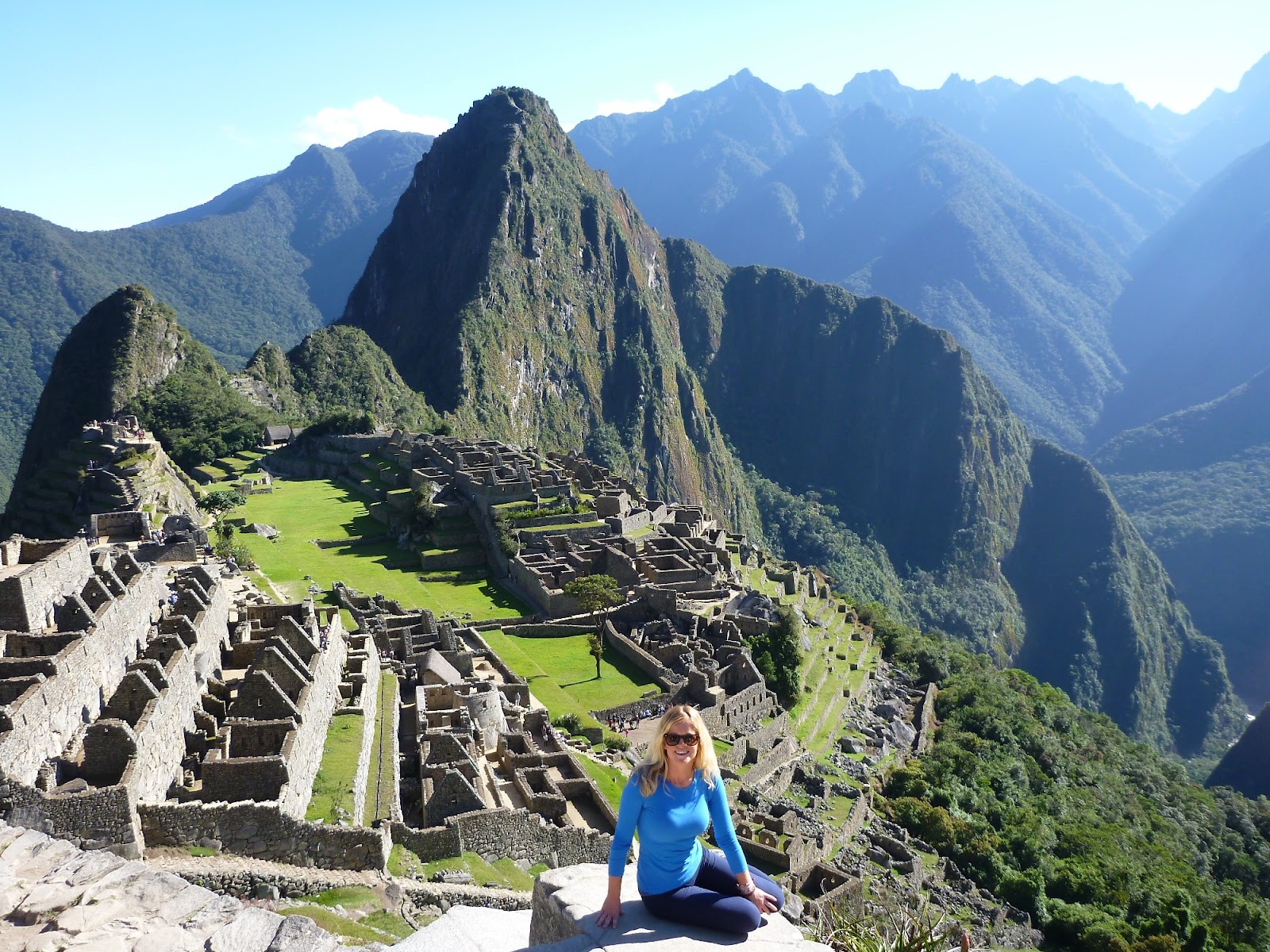
We followed the train track, twice having to hug the side as a train passed, and sneaking glimpses of Machu Picchu up above and watching people the size of ants walking on the far side of the ruins.

With our excitement about that aside, it was an ethereal landscape of jagged-toothed mountains heaved up around the latte-coloured Urubamba River. Latte, because of the sewage from Aguas Calientes and Cusco, sadly.

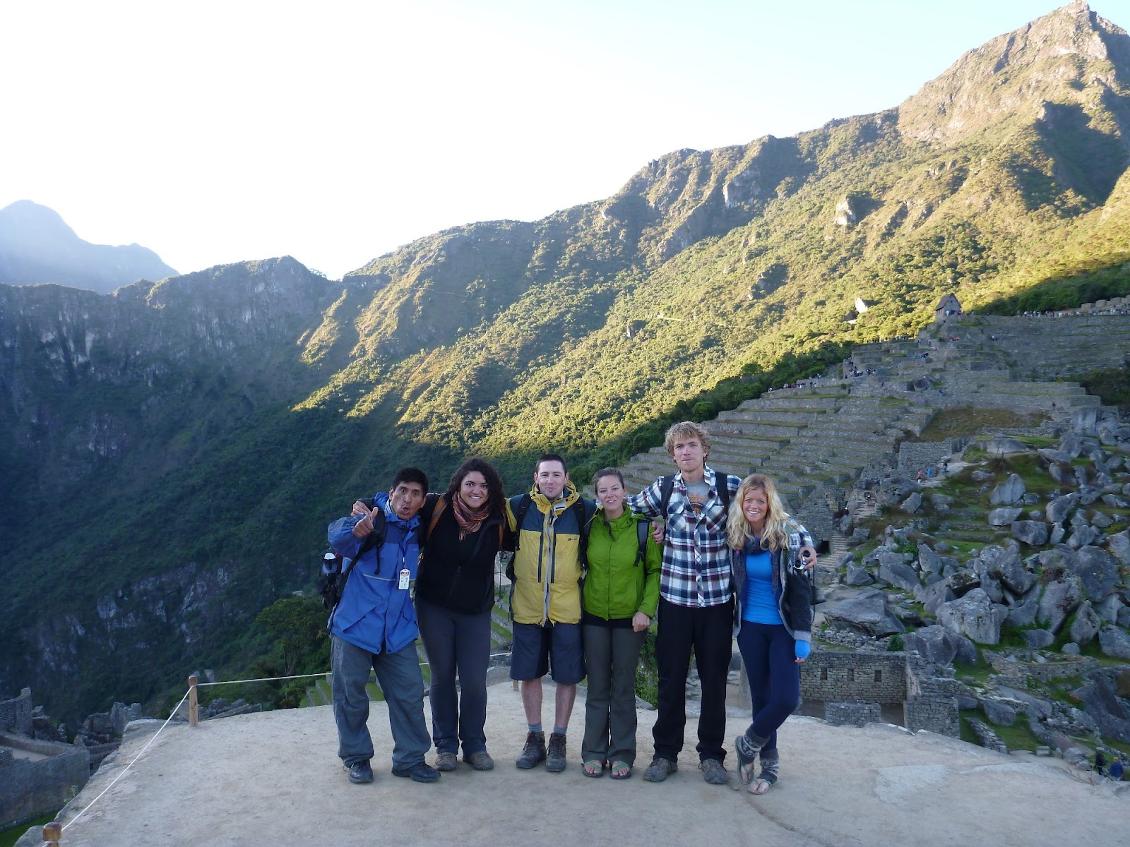
It was with a mix of excitement and relief that we finally walked up the road that runs from Machu Picchu’s main entrance to the town of Aguas Calientes.

Machu Picchu somewhere in the distance
Situated along the river, with the train tracks running straight through the centre, it’s a tourist town in the truest sense of the term. But it meant a shower, a bed and a good feed before the pièce de résistance the following day.

I was too excited to sleep.
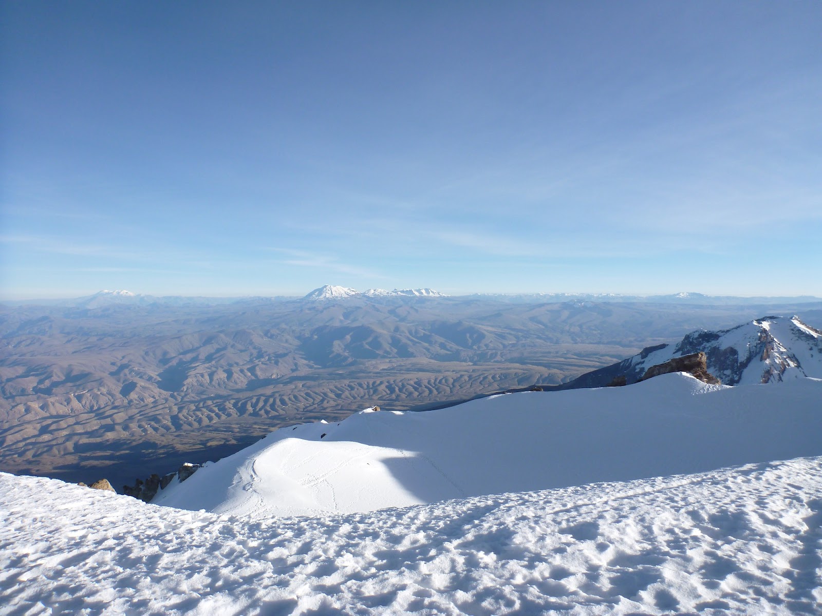
Sunday 3 June 2012

Sun worshipping on the Isla del Sol

Originating from Cusco, Peru the Inca empire once stretched north to Ecuador, south to northern Chile, east to the coast, and west through the Andes and partway into the Amazon.

Lake Titicaca
Therefore, the Inca tradition, it's tales and ancient ruins thread through some of the most beautiful parts of South America, including the Isla del Sol, in Lake Titicaca (the world's highest navigable lake).

The Isla del Sol is the legendary Inca creation site and the birth place of the sun in Incan mythology.
Inca ruins on Isla del Sol

After a night in Copacabana (sadly, there was no showgirl named Lola, with yellow feathers in her hair), we took a boat across to the island, meeting friends along the way.

Despite being 4000 metres above sea level, the sun beats down and this rather dry, dusty island to give the impression of being in the Mediterranean. The island curves around in a series of little bays, against the shores of which the water shines greeny-turquoise.
La Mesa de Sacrificio

On arrival, we traversed the cobbled streets to visit the little museum in Cha’llapampa, which contains Incan artefacts and treasures from underwater excavations in Titicaca. From there it was a good 30-40 min walk up to the north of the island, snowy mountains shimmering in the lake and donkeys sauntering along the worn pathway.

We visited La Mesa de Sacrificio (Sacrifice Table) a rock table with 12 rock chairs around it symbolising the 12 months of the year (also in the Inca calendar) and the Inca ruins here - a little taster of what was to come in the next week.

Stunning sunset
With friends, we then walked the beautiful pathway from north to south, although it came at a cost. There's an interesting - typically-Bolivia - taxing method at work on the island. At first it's 10 Bolivianos for the ruins and northern part of the island, then another 15 for the central part and, just when you think you're done, you have to pay another 5 to get into Yumani, the southern village.

We were broke by the time we had reached the end of the walk (although, now I think about it, that's less than £3 each - it's all relative!), but not too broke to afford a beer and a well overdue menu del dia.

Even more beautiful sunrise
The views and setting was bliss as we trotted up to the mirador to watch sunset. We started to believe this island really did give birth to the sun when we saw the sun go down and set the sky on fire - the deepest red I've ever seen at sunset.

It was so special we braved the dark and cold for sunrise, which was even more spectacular than sunset, a pink, milky glow turning into a raging rouge behind the white mountains- and we had it all to ourselves this time, with just another couple we had met.

This completed our sun worshipping in the Island of the Sun - I could have stayed for a week for more of those moments.